Walker Creek Projects
What’s Happening in Walker Creek?

The salmonid life cycle is key to understanding the importance of Walker Creek in the survival of endangered salmonid populations. Source
The Situation
Walker Creek watershed is important for many reasons, one of which is because it supports federally-protected coho salmon (Oncorhynchus kisutch) within the Central CA Coast Evolutionarily Significant Unit (ESU), meaning they’re genetically distinct. Coho salmon were first listed under the 1973 Endangered Species Act (ESA) as threatened in 1996 and reclassified as endangered in 2005. They live for a total of three (3) years and spend the first half of their lives in freshwater habitat. Their habitat needs are specific and include a rich, complex stream system with native canopy cover, ample fallen and live wood instream, clean spawning gravels, cool deep pools, oxygen-rich water. They also rely on a steady supply of food which is mostly comprised of benthic macroinvertebrates (BMIs) or aquatic insects that thrive in watersheds with good water quality. Walker Creek is in the spotlight with aspirations to continue improving watershed conditions. This has resulted in all of the resource agencies and partners coming together in hopes to support the return of healthy coho salmon populations once again.
Though the historic population was abundant, today there are few coho salmon remaining. Walker Creek coho numbers, however, have increased in recent years, largely due to restoration efforts which ranchers have undertaken in the last three decades. Over 50% of ranches in the Walker Creek watershed have participated in conservation projects during this time. Walker Creek land managers, your ongoing stewardship is making a difference!
We would like to better understand where we should focus our restoration efforts with ranchers. In order to do this, we need to understand where fish survival is declining within the salmon life cycle. Fortunately, there are several agencies and organizations (listed below) who are willing to help us understand the science and habitat needs of this species.
The following projects, in addition to research conducted in Walker Creek, will prove vital in understanding reproductive and recruitment success, survival, and potential limiting factors for Walker Creek coho recovery. Partnerships with landowners and local institutions are critical to the success of all of these efforts in saving a species on the brink of extinction.
As a rancher and land manager, you can continue to help by participating in the projects below.

The Projects
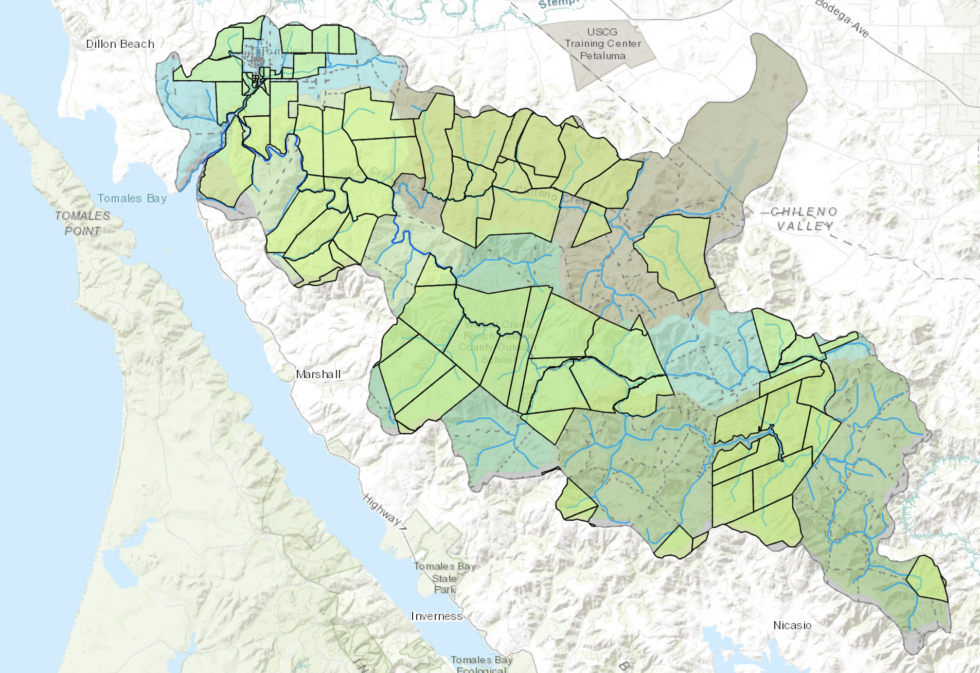
View the interactive project map in a new tab here.
Read more about each project by clicking on its title below.

The Lower Walker Creek Floodplain Habitat Assessment and Design Project (funded by CA Department of Fish & Wildlife) includes working with four landowners and collecting information to better understand the relationship between stream channels, floodplains, and existing habitat conditions for salmonids in the estuary-stream ecotone zone upstream of Highway 1. The existing conditions, as well as the site-specific opportunities to enhance or create off-channel habitats and in-stream complexity described in a Habitat Enhancement Plan will all be documented as a result of this project and further used to guide future restoration efforts in the watershed. Restoration design alternatives will be produced for three high-priority sites. The goal of the project is to provide a road map for agencies and organizations to improve rearing habitat and coho juvenile survivorship in the lower Walker Creek floodplain in addition to reducing downstream flooding. Floodplains provide the following benefits:

- create expanded areas of low flows for smaller fish to retreat to during high flow events, increasing hydraulic complexity
- provide space for fine sediment to be deposited that would otherwise negatively impact salmonids via turbidity and egg suffocation
- incorporate a wide array of food sources that are otherwise cut off from the stream channel
- include vegetation that can provide cover from predators
- reduce flooding by creating a wider area for water to spread out in a safe space
Life stage(s) benefitted: All life stages; juveniles for rearing and foraging habitat, smolts for outmigrating through desirable water quality conditions, adults entering to spawn in need of shelter during high flows in winter rain events.
Point of Contact
Sarah Phillips, Urban Streams Program Manager: sarah@marinrcd.org
Marin Resource Conservation District
80 4th St/P.O. Box 1146, Point Reyes Station CA 94956
Office: (415) 663-1170


A Smolt Trap was installed in lower Walker Creek in 2022 with the help of two participating ranches. Monitoring downstream migrating smolts is essential for estimating salmonid freshwater survival. The California Department of Fish and Wildlife (CDFW) monitors salmonids by capturing, counting and releasing smolts as they leave the watershed every day during the migration period, from mid-March to early June. The combination of adult and smolt populations help evaluate success with salmon releases (described below). Due to the high variability in salmon numbers from year to year and the Coho Salmon life cycle consisting of three relatively independent cohorts, the need for monitoring is likely to continue into the near future. Because female coho salmon are three years of age when they reproduce (spawn), every three years comprises a specific “cohort,” or different assemblage of fish that are living within that same three year life cycle together. On small streams the preferred method for capturing smolts is a fyke net, which funnels fish into a live box.
Life stage(s) benefitted: smolts
Point of Contact
David Hines, Senior Environmental Scientist | Coho Salmon Recovery Coordinator: david.Hines@Wildlife.ca.gov
California Department of Fish & Wildlife | Bay Delta Region
2825 Cordelia Road, Suite 100, Fairfield CA 94534
Office: (707) 576-2813 | Cell: (707) 656-6070


Salmonid Releases have occurred at a few ranches into Walker as part of the Coho Broodstock Program at Warm Springs Hatchery at Lake Sonoma. Historically, CA Department of Fish and Wildlife (CDFW) released coho salmon as early as the 1970’s in hopes of reviving the population and learned many lessons along the way (i.e. time of year of releases, age of fish upon release, locations in the watershed for releases, etc…). The genetics of these Walker Creek fish that are reared at the Warm Springs Hatchery are descendants of coho salmon from the Lagunitas Creek watershed. Juvenile coho have been released since 1979 varying in release numbers 15,300-18,363. Furthermore, adult coho have been released since 2003 varying in release numbers from 40-260. See the data table below for more details on releases since 2003.
Life stage(s) benefitted: adults
Point of Contact
Derek Acomb, Senior Environmental Scientist | Bay Delta Region Coho Salmon Recovery Coordinator: Derek.Acomb@wildlife.ca.gov
California Department of Fish & Wildlife | Bay Delta Region
2825 Cordelia Road, Suite 100, Fairfield CA 94534
Office: (707) 944-5522

A PIT (Passive Integrated Transponder) Array was installed at Walker Creek Ranch (WCR) at the end of 2020 in a partnership between WCR, CDFW, and CalTrout. The purpose of this pilot study is to identify patterns and timing of hatchery-released coho migration in Walker Creek. On December 15, 2020, two “PIT Antennas”) were placed in Walker Creek on WCR. Hatchery coho salmon from Warm Springs Hatchery were surgically implanted with PIT tags prior to their release, each with their own distinct Tag Number that notifies the antennas of the date and time when the fish swims over them. This data is recorded then downloaded weekly to carry out monthly analyses. Spawning season usually begins with the onset of winter rains and lasts through February. The antennas are installed in mid-December before the fish are released and maintained for the duration through the end of March.
Walker Creek PIT Project – Feburary 2022 Update.pdfWalker Creek PIT Project – December 2021 UpdateLife stage(s) benefitted: adults
Point of Contact
Pat Samuel, Bay Area Program Manager: psamuel@caltrout.org
CalTrout
(415) 392-8887 x104


A Walker Roads Assessment (funded by CA Department of Fish and Wildlife) was recently completed in the watershed over the last couple years. This project is now coming to a close with 16.2 miles of rural roads having been surveyed and prioritized for road improvement projects. This work is critical as roads tend to erode or fall into disrepair and contribute fine sediment inputs into streams. Poor water quality causes turbidity that can impair visibility, clog fish gills or invertebrate feeding structures, and settle on salmonid eggs that cut off the oxygen supply and suffocate them. The focus area for this work is along the spawning reach where salmon eggs require clean running water to survive.
Life Stage(s) benefitted: eggs & alevin. Eggs remain in the gravel throughout the winter. In the spring, the eggs hatch and alevins remain in the gravel until their yolk sacs are absorbed. Two to three months after being laid, these fish are large and strong enough to emerge from the gravel, and are then considered fry.
Point of Contact
Nancy Scolari, Executive Director: nancy@marinrcd.org
Marin Resource Conservation District
80 4th St/P.O. Box 1146, Point Reyes Station CA 94956
Office: (415) 663-1170


Marin Water (formerly Marin Municipal Water District or MMWD) has been carrying out intermittent spawner surveys and juvenile surveys. Surveying has been infrequent due to staffing constraints and inhospitable weather conditions at times as well as limitations around private property access. Marin Water has been carrying out spawner surveys since 2003 and juvenile surveys since 2005. To date, monitoring of coho salmon in Walker Creek has been limited to spawner surveys to estimate adult abundance and DNA analysis of juveniles to identify genetic diversity and whether the parents were of hatchery origin (analysis conducted by National Marine Fisheries Service). Documenting wild-origin coho salmon fry determines if the conservation goal of re-establishing a self-sustaining population is being met.
Life Stage(s) benefitted: spawners and juveniles
Point of Contact
Eric Ettlinger, Aquatic Ecologist: eettlinger@marinwater.org
Marin Water
49 Sky Oaks Rd. Fairfax, CA 94930
Office: (415) 945-1193


The Marin RCD, and partner organizations, have been constructing hundreds of projects with ranchers in this watershed since the late 1980s. Many miles of riparian area have been restored, along with the installation of critical infrastructure to support ranchers with alternative water sources such as tanks, troughs, fencing, road work, and erosion control. These projects prevent sediment and pathogens from entering Walker Creek and Tomales Bay. If you are interested in more information about our programs, please give us a call at (415) 663-1170 or contact us via email using the sidebar to the right of this page.
Life Stages(s) benefitted: all stages


Dear Walker Creek Rancher, Land Steward, and Manager,
Thank you for your interest and participation in the health of the Walker Creek watershed! Your stewardship is vital to sustaining the ecological health of our soil and water resources. Equally important is your effort to support the biodiverse species who thrive in healthy ecosystems.